Lake St. Peter Provincial Park Proposed Expansion
Map of the proposed Lake St Peter Provincial Park Expansion in light green the proposed expansion of Lake St. Peter Provincial Park. Also not the Orange ALC blocks proposed (see alternate article)
Button will take you to the Lake St Peter Provincial Park Management Plan.
Lake St Peter Prov. Park Management Plan January 24, 2021
McKLPOA
PO Box 192
Whitney, ON, K0J 2M0
www.mcklpoa.ca
ALC Intake Team
Ontario Information Centre, Algonquin Land Claim
31 Riverside Drive, Pembroke, ON K8A 8R6
Re: Lake St. Peter Provincial Park Expansion
Dear ALC Team,
The McKenzie Lake Property Owners Association (McKLPOA) is organized for the purpose of collectively representing the values and interests of its membership. Currently the association represents 50 plus properties and is growing. Our diverse membership ranges from permanent residents to seasonal cottagers who have been here generations, to those who have recently purchased property in the area. Members are both seasonal property owners along with an ever-increasing number becoming permanent residents of the area.
The proposed expansion changes to Lake St. Peter Provincial Park have been communicated to the member base for feedback and are summarized for this submission. Key topics of concern are listed below with details to follow:
- Members identified regular use of the land and waters for the purposes of:
- Fishing
- Hunting
- Kayaking/canoeing/boating
- Hiking
- ATV/UTV riding
- Snowmobiling
- Skiing
- Mountain biking
- Camping
- Berry and mushroom foraging
- Birding and other nature observing hobbies
- Geocaching
- Swimming
- Picnicking
- Annual water sampling and Secchi disk reading as part of the Lake Partner Program for both McKenzie and North Chainy Lakes
- All members considered themselves ‘good stewards’ of the land and put regular effort into ensuring:
- Cleanliness of picnic areas and trails through waste pickup
- Trails and portages remain open and safe for continued use through clearing, and regular maintenance efforts
- Loon nesting areas are preserved and monitored
- Ski trails are groomed and available (at edge of proposed park lands – not directly inside)
- Members have also expressed concerns about expansion in regards to:
- Continued hunting and fishing access while also
- Overfishing potential especially the smaller North Chainy Lake by increased public access
- Water access only (or ATV trail only) access properties surrounded by expansion lands maintaining their current level of access
- If the park is to be further developed there are concerns about
- water access (North Chainy and McKenzie) control
- camping monitoring and controls
- loon nesting and protection measures
- waste management and water quality safeguarding
- minimal alteration of visual skyline and shoreline views
- Continued hunting and fishing access while also
Purpose
It is understood that the public consultation phase is to request feedback from local stakeholders in regard to the proposed Lake St. Peter Provincial Park Expansion land use and environmental activities of the area. This letter represents the collective feedback of members (and some non-members) for this purpose. The association has attempted to identify key points of interest which are significant to its members, as well as general usage patterns and activities to assist the committee in future use and planning decisions. The McKenzie Lake Property Owners Association also wishes to remain a major stakeholder in planning and discussions of land use moving forward.
Background
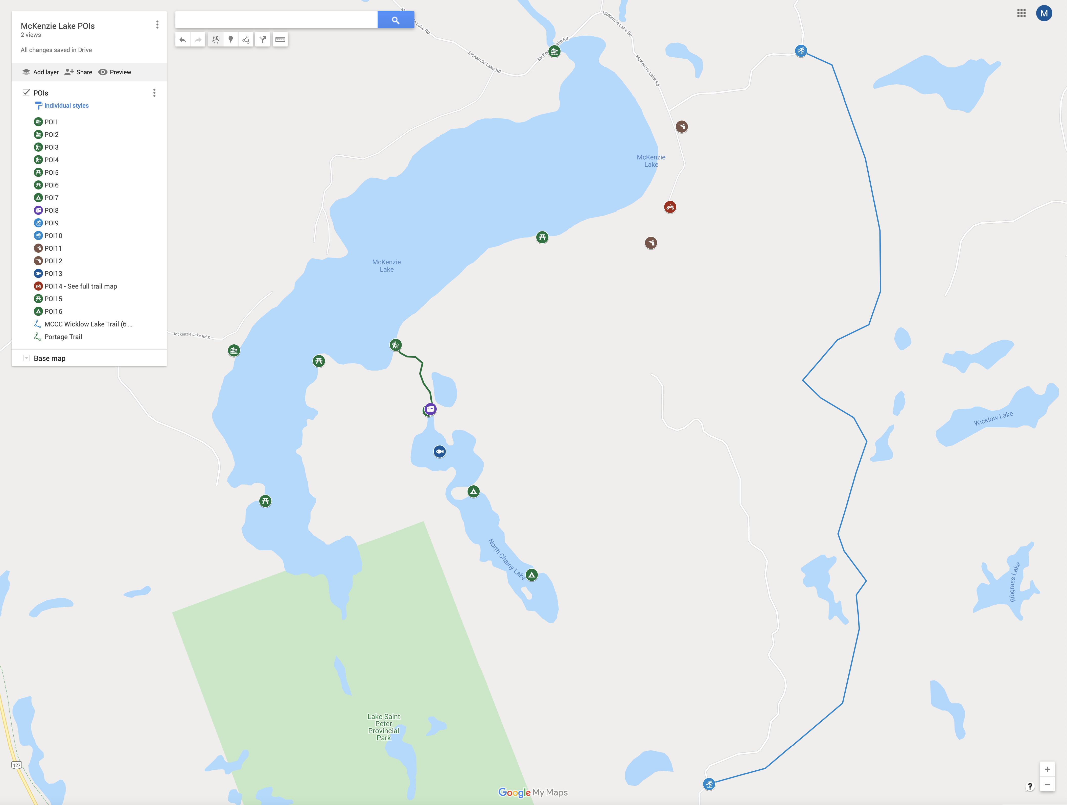
McKenzie Lake has a combination of land accessible properties (municipal and unassumed roadways) as well as water access only properties. The water access only properties are located on the eastern shore of the lake, towards its southern end. Please see the end of this letter for an overview map detailing key areas and points of interest (POI Map - https://www.google.com/maps/d/edit?mid=1z9Gjzheo0q6adQodBgAVGCc5UlCS6S7P&usp=sharing).
The lake has a public boat launch area located at the north end at the start of Moore Creek (POI1), one of the watershed primary drainage creeks of the lake. This launch can accommodate most boats large and small. McKenzie Lake also currently has a second public access point accessible from the South McKenzie Lake Road (POI2). It is currently located on Crown land but will cross the proposed Algonquin Land Claim 344a. A previous letter has already been submitted in regards to the proposed changes around this access point.
A portage path is located approximately 400 meters east of the North Chainy Lake creek entry into Lake McKenzie (POI3-4). This portage path winds its way towards the atv trail and eventually to the northern most end of North Chainy Lake.
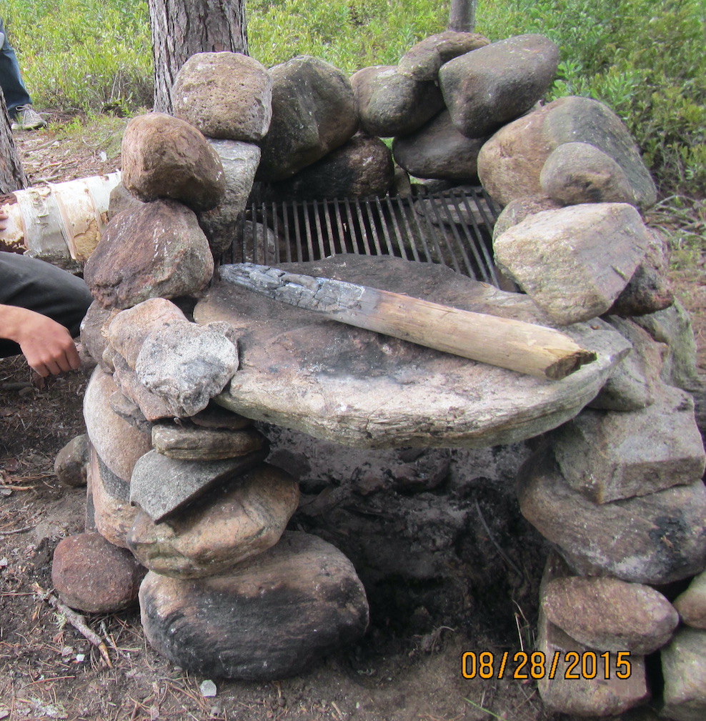
Several ‘picnicking’ and camping points are also set up and maintained by members and property owners of the area. One is located on the point directly across from Windmill point (POI5), which has a picnic table, campfire area and is frequented for camping as well as day use only. A further point closer to the existing Lake St Peter Provincial Park is setup the same on the rocky point (POI6). In addition, a third picnicking and camping spot has been established and is maintained on the southern most peninsula in North Chainy Lake (POI7). This spot members continually maintain and ensure is well kept both a protective fire pit as well as clean use of the area. See image of POI7 campfire in the appendix A.
A geocache (POI8) as part of a local involvement program also exists very close to POI4. Others are not in the proposed park expansion area.
McKenzie Cross Country Club (MCCC) also groom several ski trails around the lake area for Nordic skiers to enjoy. One of the trails appears to enter and exit briefly into the proposed expansion area (Identified on both POI map as well as Trail map), and some concern is raised about its continued sustainability and access based on future land development plans. This is a beautiful trail which involves considerable maintenance and time to keep open by a volunteer, local property owner perspective. Often the trail can’t make it all the way through in seasons where weather continually results in blowdown or limited access by the groomer.
Several property owners own and operate hunting businesses in the proposed area which has existed for generations and is a regular source of income for one camp in particular.
Details
1. Members regular use of the area in the proposed expansion block details
Members responded with many memories and activities they continue to enjoy within the proposed expansion area for up to 5 generations of families. It is a favourite activity of many members and extended families to ‘head-out’ from their properties to experience the surrounding lands for a day trip or even extended stay at one of the favourite maintained camping spots identified.
Based on member feedback and regular observations the trail network and land use access to the proposed expansion area is frequented on a DAILY basis in all seasons, excluding the use of OFSC snowmobile clubs which increase the usage in winter months.
Fishing: The use of and access to North Chainy Lake is so frequented by the member base, many have left boats at key access points and have purchased extra gear to make the regular fishing and day trips there easier and more convenient. It is common respect and courtesy to use equipment left by members and leave in same state for the next person.
Hunting: Two established hunt camps (and registered as bear management area) use the lands for the fall bear hunt as well as during deer and moose season. This includes many blinds, stands and other hunting equipment which is scattered throughout the area identified for park expansion and has been generally left there year after year.
Canoeing/Kayaking: McKenzie and North Chainy Lakes are enjoyed by members and non-members alike. Many canoe or kayak McKenzie to reach the portage trail, where they portage and continue into North Chainy Lake. Some leave their boats at the portage trail head and hike up into the North Chainy area to use boats already there or simply hike/explore the area. Others may drive the ATV trail transporting kayaks or canoes to the North Chainy access point and then access the water at the access points. For some members this is a common Saturday fishing trip, while others visit area monthly or several times in a season.
Hiking: Similar to members that access the portage trail for boat transfer to the North Chainy Lake, many use this access point or the others around the south shore to go for day hikes in the proposed expansion lands. This can often intermix with other purposes like bird watching, nature observations, along with berry and mushroom foraging. Many of the access points around the lake (many with picnic locations) are used for this purpose or some will use the main ATV trails as a hiking path or route.
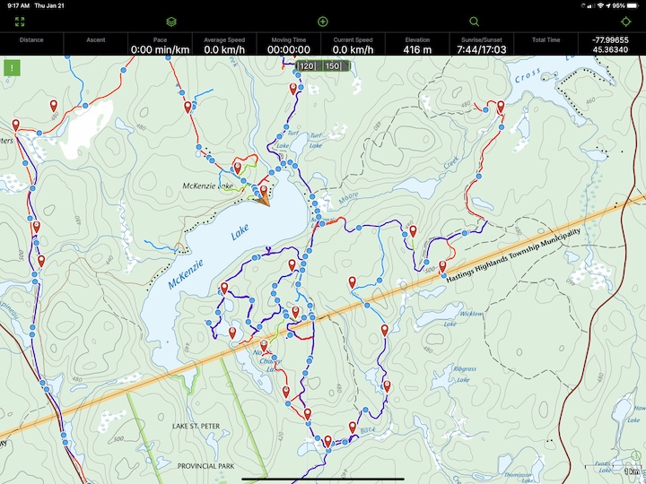
ATV/UTV riding: Members frequently enjoy trail use via ATV, UTV (side by sides) and snowmobiling in the winter months. The used trails are identified in the attached Appendix B trail use map. Many of the trails are deprecated logging roads which the members continually maintain for the purpose of atv/utv access or even winter season ski trails, etc. These trails are also essential for the water access property owners to access their properties via land.
Snowmobiling: The Maple Leaf Snow Skimmers maintain and groom the OFSC trail in District 6 which passes through the proposed expansion area. The association has several avid snowmobilers who are regular trail use permit holders and enjoy the privilege of having immediate access to the OFSC Provincial trail network in their backyard. Members wish for this land use permission to continue as it currently exists.
Skiing: Many members enjoy Nordic skiing to the extent a skiing club community has been established within our member base. This is significant enough that there are two trail maintainers and groomer machines with drags who maintain approximately 12 kms of trails. One of these trails enters and exits the proposed parkland extension along its route. Not all trails are open all the time, and this year with COVID-19 persons being able to get together to clear and maintain trails has been limited. This is an important activity for members in winter time as it is both compatible as an isolated event for individuals as well as households living together and promotes active living with outside activities in a beautiful, natural environment.
Mountain biking: Many of the ATV trails are used by mountain bikers of the association and general public. The network of closely integrated loops and points of interest makes a wonderful experience that is immediately close to home for many members and can accommodate either short or long rides along with easy or more challenging trails. This has been a great feature of engaging younger generations to get out into the natural setting with healthy activities.
Camping/Picnicking: Unofficial camping, picnicking spots have been established on both North Chainy Lake and McKenzie Lake on lands in the proposed expansion. Members and non-members alike share and use these locations, investing in picnic tables and chairs which have been left for all to enjoy. These spots are identified on the POI map in the appendix. These spots are used frequently in all seasons, and members ensure these areas are kept clean and maintained, with a leave no trace approach.
Berry and mushroom foraging: Members have favourite spots and areas in which known varieties of berries and mushrooms are common with are frequented in the appropriate times of the year.
Birding and other nature observing hobbies: Many members enjoy taking their visitors or guests on a trip into the North Chainy Lake or a land hike/walk in the proposed park extension, where they can experience undisturbed shoreline and an enclosed lake with beavers, loons, turtles and sometimes Osprey. It has been a joy to members to have the beauty of a lake ‘undisturbed’ by development where one can watch natural creatures in their natural environment continually available.
Geocaching: Part of the engagement initiatives of the association and member families to engage younger generations in both a learning (orienteering) and outdoor activity is geocaching. Local geocaches have a local area theme where one of which is inside of the proposed park expansion land. Several additional caches were planned to be added to this area which are currently under review.
Swimming: The identified picnic areas, are also common swimming areas as well as trips to North Chainy Lake also result in an enjoyable swim during the trip.
Picnicking: Similar to the above, the common spots identified as picnicking and camping areas when used as a day trip become picnic and day visit only locations. Members ensure the same leave no trace use of these areas is maintained apart from the picnic tables and features left for repeated use.
Lake Partner Program: The Environmental Committee (EC) of McKLPOA, is registered members of FOCA and the Lake Partner Program. As lake stewards, the EC is regularly involved in ensuring the Ministry of the Environment, Conservation and Parks (MECP) receive regular seasonal updates on Secchi disk readings and water sampling for analysis. In addition, the EC is commissioning a more detailed (full spectrum) water analysis of McKenzie Lake. The EC also engages members for programs like the Frog and Loon surveys, bird sightings reporting, and other environmental initiatives focused on protection and sustainability of the environment.
2. Aspects of ‘good stewards’ and maintenance in proposed expansion area
Many of these members also repeatedly commented on either monthly or annually performing tasks to help ensure and maintain the environment which is currently crown land is maintained in its current state. These activities include but are not limited to:
- Taking a garbage bag each time they go for a hike, or fishing, or camping to pick up ‘others’ garbage and debris. Members have found most of the debris left behind is vacationers, visitors, etc. who are not locals and invested in the area.
- Trail clearing and widening to prevent ingrowth, this includes cutting blow down, trimming bushes and underbrush, grading washout areas, and fixing erosion issues.
- McKLPOA along with the EC annually organize ‘road side cleanups’ to remove garbage and debris thrown from vehicles passing through the area. This includes trails in the expansion area – although that is less formally organized.
3. Member expressed concerns on future use/development of the proposed expansion area
The proposed expansion area is used by both the local property owners and visitors to the lake and area who would access it. Members have expressed questions about the following items as it would be managed as Provincial Parkland:
- Would usage require a day use or camping permit?
- Would access to North Chainy Lake and the popular points on McKenzie Lake be restricted?
- Would there be increased environmental impacts on the land and water quality through increased infrastructure?
- Would there be increased risk of invasive species through increased usage of waterways by non-locals?
- Can the proposed hunting allowances for the proposed park land extension be maintained as currently available?
- The Association is greatly concerned about the prospect of increased vehicular traffic on the North McKenzie Lake Road and increased demand for vehicular parking. Because of this concern, we would not want the plan for future development of the expanded Lake St. Peter Provincial Park to provide land access to the Park from the end of the road, nor to encourage more intensive use of the main boat launch.
- Could nesting areas or sensitive areas damaged or become too busy such that species move elsewhere or are displaced by increased human presence?
McKLPOA Respectfully Requests
Association members, particularly those most heavily impacted by the proposed park land extension have requests in regards to access/egress to private lands as well as managed camps, and the association as an active participant in land use planning moving forward.
- Written sustainable assurances that use of the trails and access to private lands, as provided by the Public Lands Act, can be maintained as they relate to access to hunt camps, and the proposed park land surrounded private property.
- That the proposed park land extension’s purpose is primarily designated as a conservation reserve and will see minimal (if any) infrastructure development.
- McKLPOA to be considered a stakeholder and involved in any infrastructure planning and proposed changes such as the establishment of permanent campsites, access points, or any other access restrictions in the land use management process.
Summary
McKenzie Lake Property Owners Association members are deeply connected to the lands and waters within the proposed extension of Lake St. Peter Provincial Park. Members and non-members alike have enjoyed the freedom to use the public land under the Public Lands Act for hiking, fishing, swimming, canoeing and hunting for generations and feel responsible for conserving their beauty and environmental health. Members have long been wary of development of the south shoreline and beyond crown land, where previous landowners have fought hard to preserve its current natural state. The association wishes to ensure current and future generations will be able to enjoy the lands in their natural undeveloped state its members have come to enjoy and have invested care in for many generations.
Sincerely,
McKenzie Lake Property Owners Association
APPENDIX A – PHOTOS
POI7 – North Chainy Lake campfire for camping, fishing and day use spot on the peninsula.
APPENDIX B – POI MAPs
- General Points of Interest (POI) map of lake and points in the proposed Park expansion area. (https://www.google.com/maps/d/edit?mid=1z9Gjzheo0q6adQodBgAVGCc5UlCS6S7P&usp=sharing)
- ATV/UTV/snowmobile/hiking trail use map (NOTE: extended trail access to get to the water access only properties is not shown on this map)
Lake St. Peter Provincial Park Management PLan (2016)
Map of current Park boundries, along with a link below to the official Lake St. Peter Provincial Park Management Plan, approved in 18 Jul 2016. Click button to view full management plan.
Management Plan (2016)EER Response to Questions
Hi Chris,
For the Tuesday November 24th call at 10am, please find the following Teleconference information:
Dial: 1-866-602-5423
Passcode: 2735966
As well, here is further information in response to your two previous questions:
“I am puzzled however, that an environmental assessment would not be tied to park management planning. Should there not be an assessment as to what development or not is environmentally acceptable vs too impactful? This would further dictate capabilities one might presume.”
Under the Environmental Assessment Act, only those activities deemed to be undertakings are subject to the requirements of the Act. The class of undertakings contained with the Algonquin Land Claim Declaration Order includes the amending and rescinding in whole or in part, boundary regulations for provincial parks and conservation reserves. The assessment related to the recommended Whiteduck Provincial Park boundary establishment project looks at the impacts of the establishment of a provincial park boundary by regulation (i.e., the effects of change that occurs in changing general use Crown land or conservation reserve to a provincial park). The summary of net effects provided in the Draft Environmental Assessment Summary Report acknowledges that there is variation in the rating of potential effect (i.e., low positive/low negative or medium positive/medium negative) associated with various criteria and that rating considers that there may be some uncertainty of the effect where decisions are subject to the park management planning process. For clarity, management planning for a provincial park or conservation is not an undertaking subject to the EAA.
Once a boundary of a provincial park or conservation reserve is established by regulation (in the case of Whiteduck Provincial Park and the addition to Lake St. Peter Provincial Park that regulation would occur after the ratification of a Final Agreement), the PPCRA requires that the Minister ensures that the Ministry prepares a management direction for that provincial park or conservation reserve. The management direction is approved by the Minister (or their delegate) and identifies site specific management policies for the provincial park or conservation reserve. This management planning process is subject to consultation requirements as set out in the PPCRA and the Environmental Bill of Rights Act. Specific projects, including resource management, development and related operations enabled in the management direction through the management planning process would then be subject to the Environmental Assessment Act requirements. The requirements also have processes with regard to evaluation and consultation that must be followed. So you are correct that various projects and activities are assessed for their environmental effects, but not at the time of boundary establishment.
How much of your current process is enabled/affected by Bill 197?
The Environmental Assessment Act provides the framework for the environmental assessment process in Ontario - a planning and decision-making process designed to consider environmental effects before a project begins. Bill 197, COVID-19 Economic Recovery Act, 2020 is part of Ontario’s broader modernization of environmental assessment requirements. The current Algonquin Land Claim Declaration Order is not affected by this Act and the Declaration Order continues to apply.
The Algonquin Land Claim Declaration Order was approved in 2007 and applies to EA processes related to potential elements of a settlement of the Algonquin land claim within the negotiations process and to ensure that Ontario’s EA obligations are fulfilled in an open and transparent manner.
Thanks again for reaching out to us for more information and we look forward to speaking with you on Tuesday morning.
Lesley
EER Response to Submission